6. Strategic objective 1 to 4: voluntary targets, additional indicators and affected areas
6.1. Voluntary targets for strategic objective 1
6.1.1. Introduction
Parties may wish to set national voluntary targets that contribute to strategic objective 1 (SO 1) and therefore “to improve the condition of affected ecosystems, combat desertification/land degradation, promote sustainable land management and contribute to Land Degradation Neutrality (LDN)”.
This includes, but is not limited to, the formulation of LDN voluntary targets in accordance with Parties’ specific national circumstances and development priorities. LDN voluntary targets reflect Parties’ ambitions in achieving no net loss of (and thus neutrality), or gains in, healthy and productive land when compared to the baseline.
The definition of voluntary targets should be based on best available data and knowledge. The assessment of land degradation and its drivers plays a key role in informing the decision-making process. Relevant stakeholders must be involved in the voluntary target definition process to ensure ownership and that the achievement of LDN does not come at the expense of adverse social and ecosystem impacts.
Targets need to be measurable to monitor progress. Parties are invited to formulate quantifiable, geographically explicit and time-bound voluntary targets aiming at achieving a neutral (no net loss) or improved (net gain) state of the land, and defining interventions that contribute to avoiding, reducing and reversing land degradation, in line with the LDN response hierarchy (see figure 5).
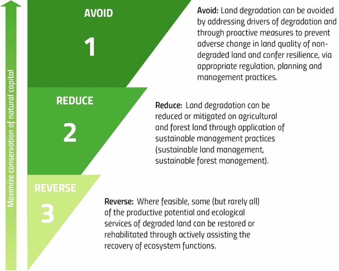
Figure 5. Land Degradation Neutrality response hierarchy
Geographic specificity helps define realistic targets. Geographically explicit targets with distinct locations, ecosystem types and maps can provide increased focus on critical hotspot areas, aid prioritization and help create realistic and purposeful sub-national commitments and plans.
An example of a time-bound, measurable and geographically explicit LDN voluntary target set by Colombia is: “By 2030, the productivity of at least 2,000 ha of soils with crops and/or pastures will be improved, with agroforestry production systems in the Caribbean and Andean regions (Sucre, Santander and Boyacá departments)”.
LDN is intended to be achieved at the national level. Countries typically aim to achieve this through the definition of a combination of national target(s) and complementary targets at the sub-national level for a specific indicator and/or a specific geographic area (i.e., a particular ecosystem, natural area, watershed or subnational administrative jurisdiction), which together contribute to realizing Parties’ ambitions in achieving or exceeding LDN at the national level. Generic examples of LDN targets at different levels of application are presented in table 26 below.
Level of application |
Example |
|---|---|
National level (no net loss) |
“Achieve Land Degradation Neutrality (LDN) by 2030 compared to the 2015 baseline” |
National level (net gain) |
“Achieve LDN by 2030 compared to the 2015 baseline, plus an additional 10% of the national territory has improved” |
Sub-national level (no net loss) |
“Achieve LDN in the Western province of country X by 2030 compared to the 2015 baseline” |
Sub-national level (net gain) |
“Achieve LDN in the Southern province of country X by 2030 compared to the 2015 baseline, plus an additional 25% of the province territory has improved” |
Specific target (to avoid land degradation) |
“Halt the conversion of forests and wetlands to other land cover classes by 2020” |
Specific target (to reduce land degradation) |
“Reduce the rate of soil sealing (conversion to artificial land cover) by 50% by 2030 compared to the 2015 baseline” |
Specific target (to reverse land degradation) |
“Improve productivity and Soil Organic Carbon stocks in cropland and grasslands by 2030 compared to the 2015 baseline” |
Voluntary targets and actions undertaken to address land degradation can simultaneously contribute to climate change mitigation and adaptation, biodiversity conservation and multiple Sustainable Development Goals (SDGs). Thus, there is considerable potential for synergies and it is very important that LDN targets ensure policy coherence and alignment with other national commitments made under different Conventions and related initiatives (i.e., Nationally Determined Contributions, National Adaptation Plans, National Biodiversity Strategies and Action Plans, land restoration commitments). In this context, LDN targets should be seen as an effective means of complementing and strengthening other country commitments and avoiding duplication of efforts.
6.1.2. Prerequisites for reporting
An in-depth reading of the LDN Target Setting technical guide.
A pool of national experts that report across various Conventions and related initiatives to ensure alignment and coherence between LDN-relevant national commitments.
A spatial data file of the target areas or a good understanding of the location and extent of the targets, allowing them to be reported on in a spatially explicit manner using the PRAIS 4 spatial data viewer.
6.1.3. Reporting process and step-by-step procedure
The step-by-step procedure for reporting is as follows.
Step 1. Declare national voluntary targets
National voluntary targets are reported in table SO1-VT.T1 of the PRAIS 4 platform. Parties are invited to articulate, in quantifiable and time-bound terms, voluntary targets that contribute to LDN and/or SO 1 and to include information on the expected year of target achievement, location and total target area, type of LDN intervention (i.e., relevance of the target to the LDN response hierarchy), planned or ongoing measures to achieve the target, and the status of target achievement. Since targets set under the United Nations Convention to Combat Desertification (UNCCD) can also address commitments made under other Rio Conventions and associated initiatives, Parties may also indicate other existing goals of relevance for their LDN targets.
Table SO1-VT.T1 is a spatial table and therefore should ideally be completed with the support of the Geographic Information System (GIS) tools available in PRAIS 4. The PRAIS 4 spatial data viewer enables Parties to delineate the location and extent of their targets, thereby making them geographically explicit, or to upload an existing spatial file (in vector format) of the target areas. This is an additional and optional element, but such location-based information can strengthen spatial approaches to sustainable land management and help integrate responses to land degradation at the landscape scale.
Additional information not included in the table may be reported in the “General Comment” field.
Step 2. Describe implemented actions relevant to the targets
Areas of implemented action (projects and initiatives on the ground) related to the targets can be reported on in table SO1.IA.T1. As for Step 1, areas of implemented action should ideally be delineated in the PRAIS 4 spatial data viewer.
Delineating voluntary targets and related actions currently under implementation can help track progress towards achieving LDN in a country by 2030, support the quantification of any remaining gaps and develop scenarios for closing those gaps. In addition, the UNCCD can use this spatial data to create information products to demonstrate the impact of the Convention and global progress towards LDN.
6.1.4. Dependencies
Although there is no direct dependency between the voluntary targets and SO 1 indicators, it is expected that the results of the geospatial analyses for the estimation of the proportion of degraded land will inform the definition and spatial delineation of the voluntary targets and related projects and initiatives on the ground.
There is a dependency between the targets set in table SO1-VT.T1 and the implemented actions reported in SO1.IA.T1; each reported action in table SO1.IA.T1 should correspond to one or more targets reported on in SO1-VT.T1.
6.1.5. Challenges
National coordination
With respect to the various plans and commitments formulated under the Rio Conventions and/or other related initiatives, there is the risk of lack of coherence, overlap and duplication of efforts. There is scope for better alignment on restoration in national plans between the three Rio Conventions, which could enhance planning and implementation.
National voluntary targets need to be well-defined, measurable and time-bound to monitor progress. The availability of GIS tools in PRAIS 4 may support the definition of more accurate and realistic targets in defined locations.
6.1.6. Further reading
LDN Target Setting – A technical guide (https://knowledge.unccd.int/publication/ldn-target-setting-technical-guide)
Achieving Land Degradation Neutrality at the Country Level: Building Blocks for LDN Target Setting (https://www.unccd.int/publications/achieving-land-degradation-neutrality-country-level-building-blocks-ldn-target-setting)
Goals and Commitments for the Restoration Decade. A global overview of countries’ restoration commitments under the Rio Conventions and other pledges. © PBL Netherlands Environmental Assessment Agency, The Hague, 2020, PBL publication number: 3906 (https://www.pbl.nl/sites/default/files/downloads/pbl-2020-goals-and-commitments-for-the-restoration-decade-3906.pdf)
6.2. Voluntary targets for strategic objectives 2, 3 and 4
6.2.1. Introduction
Parties may wish to set national voluntary targets that contribute to the achievement of SOs 2, 3 and 4:
SO 2: to improve the living conditions of affected populations;
SO 3: to mitigate, adapt to, and manage the effects of drought in order to enhance resilience of vulnerable populations and ecosystems;
SO 4: to generate global environmental benefits through effective implementation of the UNCCD.
The definition of voluntary targets should be based on best available data and knowledge. The assessment and estimation of the related indicators can play a key role in informing the decision-making process.
Targets need to be measurable to monitor progress. Parties are invited to formulate quantifiable, time-bound and, where relevant, geographically explicit targets.
Voluntary targets and actions undertaken to achieve the UNCCD SOs can simultaneously contribute to climate change mitigation and adaptation, biodiversity conservation and multiple SDGs. Thus, there is considerable potential for synergies and it is very important that targets set under the UNCCD ensure policy coherence and alignment with other national commitments made under the SDGs, different Conventions and related initiatives.
6.2.2. Reporting process and step-by-step procedure
The step-by-step procedure for reporting is as follows.
Step 1. Declare national voluntary targets
Parties are invited to articulate, in quantifiable and time-bound terms, voluntary targets that contribute to the achievement of SOs 2, 3 and 4, and to include information on the expected year of achievement or actual year (if already achieved), the level of application (e.g., national, sub-national) and the implementation status (achieved, not achieved, ongoing, extended or postponed, partially achieved).
Delineating the SO 2, 3 and 4 target areas in PRAIS 4 is not requested at this stage. However, geographically explicit targets with distinct locations can help create realistic and purposeful sub-national commitments and plans.
Step 2. Provide any complementary information
Complementary information may be reported in the “General Comments” field. This may include whether the targets have been adopted or officially endorsed and if so, by which body (institution, government agency, regulation). Implemented action, such as target-related projects and initiatives on the ground can also be described.
Furthermore, Parties are encouraged to outline the linkages with the SDGs, indicate opportunities to create leverage and synergies with their countries’ socio-economic, infrastructural and biodiversity agendas, and collaborate with other multilateral environmental agreements.
6.3. Additional Indicators
6.3.1. Introduction
Additional indicators at the national and sub-national levels can assist in both interpreting and understanding the common global indicators associated with each strategic objective, and address locally-relevant issues.
6.3.2. Reporting process and step-by-step procedure
The step-by-step procedure for reporting is as follows.
Step 1. Report any national additional indicators
Countries are encouraged to identify complementary indicators for SOs 1 to 4 to better address national and sub-national specificities. These can be additional progress indicators or process indicators to monitor whether actions are being implemented as planned. Additional indicators can be quantitative and qualitative.
While sex-disaggregated data related to exposure of population to land degradation and drought are now collected through indicators SO 2-3 and SO 3-2, Parties are encouraged to identify further gender-responsive socio-economic and demographic indicators that may provide a better understanding of how and why specific populations are affected by land degradation and drought.
Additional indicators can be added on the PRAIS 4 platform via a dedicated form (referred to as AI for brevity in PRAIS 4). Parties may specify the name of the indicators, the associated SOs and their direction of change. A brief description of the indicators and other relevant information may be reported in the “Comment” field.
6.4. Affected Areas
6.4.1. Introduction
By its decision 11/COP.14, the Conference of the Parties requested the secretariat to further facilitate reporting on SOs 1, 2, 3 and 4 by, inter alia, including additional data fields specific to affected areas in the reporting system.
Therefore, PRAIS 4 facilitates countries that wish to report on affected areas as an additional and optional item to national reporting. Parties have the option to report on affected areas using a specific set of forms for SOs 1, 2, 3 and 4. The process, forms and tables to report on affected areas are the same as those used for national reporting. No default data is made available for affected area reporting.
6.4.2. Pre-requisite for reporting
Sub-national data specific to affected areas.
6.4.3. Reporting process and step-by-step procedure
The step-by-step procedure for reporting is as follows.
Step 1: Define affected areas
Parties wishing to report on affected areas are invited to specify the affected area definition in use in their country. In PRAIS 4, Parties may opt to use the definition of the affected areas contained in Article 1 of the Convention1, or to provide the operational definition of affected area in use in their country.
Once this part of the form has been completed and saved, the reporting forms for SOs 1 to 4 specific to affected areas (referred to as AA for brevity in the reporting forms) will open. These forms will not contain pre-filled default data as provided for national reporting. Therefore, Parties will be required to produce the data specific to affected areas and report it in the forms as explained in Steps 2–4.
Step 2: Delineate affected areas
Parties will be required to spatially delineate the area that corresponds to the definition provided in Step 1 above. Digitization tools in any GIS software (e.g., ArcGIS, QGIS) could be used for this purpose or Parties may have an existing spatial file of the affected area available (e.g., ESRI shapefile, GeoJSON or any widely accepted file format).
Step 3: Calculation of affected area estimates for all indicators
Using the shapefile of the affected area produced in Step 2, Parties should calculate affected area estimates of all indicators for SOs 1 to 4.
Trends.Earth can be used to run these calculations on any area of interest. When calculating the indicators in Trends.Earth, Parties should upload the shapefile of the affected area produced in Step 2 and use it as the area of analysis. Parties should refer to the Trends.Earth documentation for further information on how to use their own area file in the calculations. Once the processing is complete, Parties will be required to upload their results to the PRAIS 4 platform and/or manually fill in the affected area forms with the required information.
For non-geospatial indicators (e.g., SO2-1, SO2-2, SO4-2 andSO 4-3), Parties may wish to assess the availability of sub-national information specific to the affected areas defined in Step 1, and report it in the forms provided.
Step 4: Generate reports
All forms and tables on the PRAIS 4 platform for reporting the affected areas should be filled in and supporting data and information provided, if desired, through the upload tools in PRAIS.
Once completed and verified by the Parties, the indicators’ estimates for the reporting and baseline periods should be officially submitted to the UNCCD. Parties are also encouraged to submit narratives on the methodology, data sources and data accuracy.
6.4.4. Challenges
Data availability and quality
Depending on the extent of the affected areas, spatial resolution of global default datasets available in Trends.Earth might not always be suitable to calculate indicators with enough sensitivity to spatial variation at sub-national level. Although higher spatial resolution data might be needed, Parties might be challenged by access to commercial satellite imagery, for example, where costs might be prohibitive.
Methodological approach
Affected area definitions may vary across countries, limiting the comparability of results across regions and/or globally.
6.4.5. Summary (main actions)
Key actions for reporting on affected areas are as follows:
Define affected areas: Parties should specify the affected area definition in use in their country.
Delineate affected areas: Parties should spatially delineate the area that corresponds to the definition provided in Step 1.
Calculation of affected area estimates for all indicators: using the shapefile of the affected area produced in Step 2, Parties should calculate affected area estimates for all indicators.
Generate reports: Parties should fill in the reporting forms for SOs 1 to 4 specific to affected areas.
- 1
Article 1 of the Convention defines as “affected areas” arid, semi-arid and/or dry sub-humid areas affected or threatened by desertification